
Interpretation of Flood Hazard Frequency for the Project Upazilas according to Map
(Source: BARC)
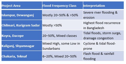
Based on the Flood Hazard Frequency Map of Bangladesh, the selected project areas fall within high hazard-prone regions. Riverine upazilas (Islampur, Dewanganj, Chilmari, and Kurigram Sadar) exhibit very high annual flood recurrence, with large portions classified under >50% flood frequency. Conversely, coastal upazilas (Koyra, Dacope, Kaliganj, and Shyamnagar) show mixed tidal flood classes, with many unions under 20–50% flood frequency due to storm surge and drainage congestion. The southeastern hill districts (Chakaria and Teknaf) reflect moderate flood frequency, influenced predominantly by flash floods and monsoon rainfall.
Riverine Upazilas (Islampur, Dewanganj, Chilmari, Kurigram Sadar)
- HF: Moderate to very high (6–20%, 20–50%, localized >50%)
- Hazards: Annual/flash floods, riverbank erosion, channel shifting, char formation
- Gendered risks: Male out-migration → more female-headed households; women face higher vulnerability in shelter, sanitation, safety, and access to services
Coastal Upazilas (Koyra, Dacope, Shyamnagar)
- HF: High to very high (20–50%, >50%)
- Hazards: Cyclones, storm surges, tidal flooding, salinity intrusion, embankment failure
- Gendered risks: Repeated damage to housing/agriculture; increased water/sanitation burdens; higher care responsibilities during disasters; dependency on vulnerable natural resources
 Coastal/Hill-Adjacent Upazilas (Chakaria, Teknaf)
- HF: Moderate to high (6–20%, 20–50%), with localized high-risk pockets
- Hazards: Flash floods from hill streams, coastal erosion, tidal flooding, landslides (Teknaf)
- Gendered risks: Disruption of roads/markets; women in informal/home-based livelihoods most affected; limited safe shelter access